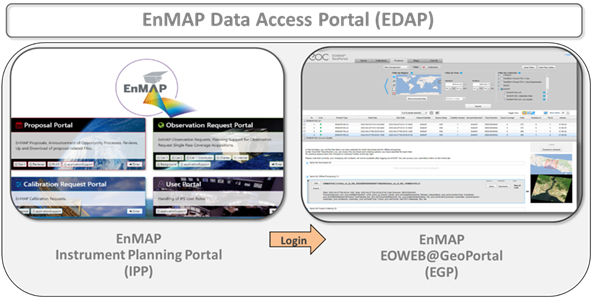
The Data Access Portal includes two major entry points: the EnMAP Instrument Planning Portal and the EOWEB® GeoPortal. Additionally, users can directly access [Analysis Ready Data (ARD)] via the EOC Geoservice and EoLAB
On the EnMAP Instrument Planning Portal registered users can submit proposals, plan, and request future orders. More information on using the EnMAP Data Access Portal is available in the user manual and in short video screencasts linked in the menu on the left.
On the DLR multi-mission web portal EOWEB the complete EnMAP Mission archive is available, where users can select the product level (L1B, L1C, L2A) for on-demand processing with the most up-to-date processors version. Additionally, users can choose more processing options (e.g., atmospheric correction over water) to obtain more precise results.
The EOC Geoservice provides immediate access for product downloads and facilitates the retrieval of large volumes of EnMAP data.
The EO-Lab platform offers a data explorer and direct access to L2A data, as well as a processing environment to analyze the data for research and development purposes. For further information please contact EO-Lab user support or consult EO-Lab help.
All recorded data is processed to L2A ARD format using EnMAP’s Ground Segment processors and default parameters. The default processing parameters of the L2A ARD are the following:
- Product_Format = GeoTIFF+Metadata
- Map Projection = UTM_Zone_of_Scene_Center
- Image Resampling = Bilinear_Interpolation
- Correction Type = Land_Mode
- Cirrus Haze Removal = No
- Band Interpolation = No
- Terrain Correction = Automatic
- Water Reflectance Product = Normalized_Rrs
- Water Type = Turbid
- Season = Automatic
- Ozone column = Automatic
Please be aware of the following:
- the versions of the L2A ARD products may differ depending on their generation time. The processor changelog (https://www.enmap.org/data/doc/EnMAP_processor_changelog.pdf) provides an overview of the software changes
- The L2A ARD archive is still being completed and will continue to grow, including more EnMAP scenes in the coming months.
Product Levels
The following EnMAP data products are available to the user community: Product Level 1B, 1C, and 2A. Please, note that the raw data and the subsequent Level 0 products are not available to the user community. This section provides a short definition of these products, a more detailed description can be found in Guanter et al. (2015) and Kaufmann et al. (2016).

The systematic/radiometric correction processor converts raw image pixels values to at-sensor radiance physical values
The geometric correction processor orthorectifies images using different methods and performs the resampling of the image (with and without automatically extracted GCPs)
The atmospheric correction processor produces reflectance values for land and water areas and generates several quality masks.
The output processor generates the final image product and masks as well as the metadata and history files.
Processing and delivery of Level 1B, Level 1C and Level 2A products are to be conducted within a maximum of 6 days after completion of the corresponding downlink. The user can choose the image format (BSQ, BIL BIP, JPEG2000 or GeoTIFF). The metadata is always in Extensible Markup Language (XML) format.